Blog

Waves of Denticles and my Art-Science Journey

By Vicky Chan

As a part of an Art and Sciences course I took this past spring quarter at UC Santa Barbara, I learned about THEMAS, practiced making digital art, and created a 3D sculpture made of shark denticles.

So what exactly is THEMAS? THEMAS stands for Technology, Humanities, Engineering, Mathematics, Art, and Science. Throughout the course, we explored topics ranging from how helicopters work to the thoughts of Greek philosophers. We were encouraged to make things and learn how to ‘swim’ by engaging with these works. I entered this class wondering how the Arts and Sciences were connected, and I came to realize how highly interconnected all these themes are. For the final project, we were challenged to create a mediated world encompassing THEMAS, based on a subject and artistic media of our choice.

Inspired by this final assignment, I took the initiative to learn a new tool: 3D modeling. I began by trying different programs and chose Blender, an open-source 3D modeling program. Blender is very versatile and offers basic to advanced features for modeling. However, one can start with a template shape and use the 3D grid space to place vertices in order to build any shape one can imagine.

At the same time as taking the class, I was also working with the Baseline Caribbean team on a research project involving shark dermal denticles. I realized that this would be a great opportunity to showcase shark denticles in the form of a 3D sculpture. The relationship between denticle morphology and the functional properties of shark denticles is quite fascinating. Inspired by how different groups of denticles are arranged on the skin, I decided to model several basic denticle morphotypes and create an artistic piece that would bring awareness of denticles and their intriguing diversity of forms to the public.

dd1

Learning how to work in 3D space was a challenge at first, as there were many different shortcuts to create new vertices and edges. I gradually got the hang of creating the denticle base first, then the crown.

dd2

These were the final denticle models I created. (From left to right: a drag reduction denticle, a generalized function denticle, and an abrasion strength denticle.)

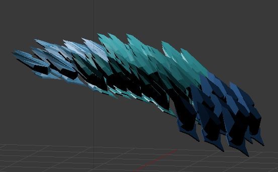
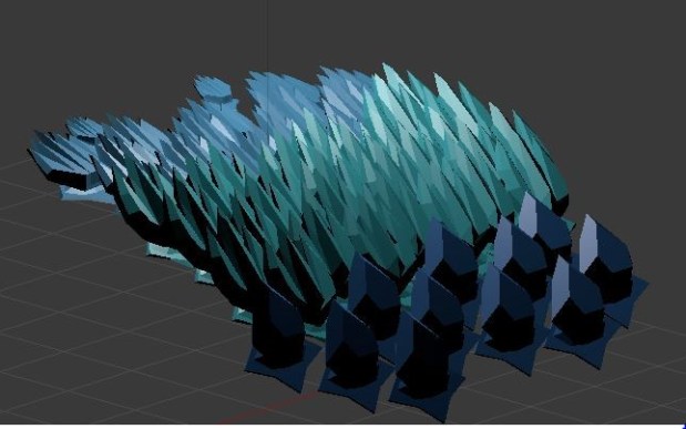
I then layered these denticles in 3D space, shifting the angle of the denticles ever so slightly and recreating a motion that is similar to a wave in the ocean.

Here is the finished 3D sculpture:

dd3

dd4

This is a mediated world, as it draws from elements of both reality and fiction. I created the shark denticles based on actual denticle morphology and arrangement patterns on the skin but used fictional sizes and colors to create an artistic composition. I’m glad that this class gave me the motivation to create an informed piece like this and for revealing to me more connections between Art and Science.

Advertisement

Historical hypoxia

Bocas del Toro in Caribbean Panama is one of the few regions in the tropics that have been demonstrated to experience widespread hypoxia, or lack of oxygen in the water, which kills pretty much everything on the reefs except slime and jellyfish.

Andrew Altieri and colleagues documented the process. They leave us with the sobering conclusion that hypoxic events like these are almost certainly more widespread in tropical reefs around the world but are drastically under-documented because most marine scientists don’t live in the tropics and so tend to miss them because they are short lived. When scientists do find a dead reef, it’s not usually hypoxia that they blame.

One important question that is left hanging is how frequent were such events in the past? Are they increasing in frequency as eutrophication increases and the water warms, or have they been a natural process on these reefs for millennia?

We have begun a project to try and explore this question by taking reef cores and looking for tell tale signs of hypoxic events in the past.

We just returned from Bocas del Toro where we extracted 6 reef cores. We were joined by STRI post-docs Noelle Lucey, Jarrod Scoot and Blanca Figuerola, along with STRI intern Ramiro Solis. Blanca is leading the project and will be extracting material from the cores and conducting faunal analysis and stable isotope analyses with Ethan Grossman in Texas A&M.

Here the O’Dea Lab team extract a 3m-long core from a shallow Porites reef in Cayo Adriana, Bocas del Toro.

The project is funded by SENACYT

¿A dónde se fueron las playas blancas?

Llegué a Panamá por primera vez en 1998. En esta época era un joven estudiante y me atraía y fascinaba la vida marina en ambos lados del istmo. Era mi primera vez en las Américas y toda era una aventura. Sobreviví a tres cosas: a una disentería en Bocas del Toro, al atropello por un taxista en la ciudad de Panamá y a la caída de un coco sobre mi cabeza en Isla Grande, Provincia de Colón. Salí del país prometiendo nunca volver. Pero, como dije al principio, Panamá goza de una extraordinaria vida marina que cautiva al primer contacto con ella. No hace falta decir que ahora hace ya 16 años que vivo en Panamá con mi familia panameña.

En esa primera visita a Isla Grande, en la zona llamada Costa Arriba, me encontré con una exquisita extensión o lengua de arena blanca que iba desde la esquina suroeste de la isla a más de 150 metros hacia mar adentro. En esta época, buceé con una dinastía de peces brillantes; en la noche dormí sobre las blancas y suaves arenas de la playa, que imaginaba como una gran cama de harina. Hoy día, la playa se ha ido y no hay peces. ¿Qué ocurrió?

isla grande donde se fue la playa

La erosión de la playa es un proceso natural que ha ocurrido durante miles de años, en donde la arena es arrastrada por la acción de la lluvia o las olas, y es reemplazada por arena nueva, algunas veces más, algunas veces menos, por lo que la playa cambia de forma. Entonces, ¿por qué las arenas no regresaron a Isla Grande?

La respuesta es bastante interesante y algo desconcertante. Resulta que la suave harina blanca que nos encanta en nuestros pies en realidad está hecha de pequeños pedazos de coral que fueron comidos y luego defecados por animales como los peces loro. Sí! Las playas blancas del Caribe están hechas de excremento de peces. Algunos científicos han estimado que un solo pez loro puede producir una increíble tonelada de arena en un año. ¿Cómo lo midieron?, no les pregunté!

Por consiguiente, cuando se eliminan los peces loro del arrecife por la sobrepesca, llega un momento en que la arena erosionada es mayor que la arena que se forma, y la playa desaparece rápidamente. No más peces, no más playa. Agregue a eso el impacto de la contaminación y el calentamiento global sobre los corales, y tendremos una receta perfecta para el desastre.

El resultado no solo se muestra en imágenes de satélite, sino también en los recuerdos de quienes alguna vez disfrutaron de estas playas espectaculares. Las personas en las comunidades costeras desde Bocas del Toro hasta los Cayos de Guna Yala, están viendo desaparecer sus playas de arena blanca.

¿Cómo lo detenemos? En papel es sencillo: mejorar la salud de los corales y aumentar el número de peces loro; y las playas volverán. En la práctica, podemos buscar historias de éxito en otros lugares del caribe. En Punta Cana, República Dominicana, conocen el valor económico de sus playas de arenas blancas. Estimaron que con cada metro de playa perdida, el país pierde más de 300,000 dólares en ingresos del turismo cada año (Wielgus et al. 2010). En Punta Cana establecieron zonas dónde estaba prohibido pescar que permitieron la recuperación del pez loro y en consecuencia de los arrecifes. También, emprendieron una fuerte campaña para cultivar nuevos corales donde anteriormente existían. Es un modelo que tiene sentido desde el punto de vista comercial y podría aplicarse en cualquier parte del mundo si cuenta con una iniciativa correcta y regulada. Las playas de Panamá son un tesoro nacional que vale muchos millones de dólares en turismo. Son una protección frente al aumento del nivel del mar y a las tormentas como el infrecuente, pero mortal, huracán Otto. Brindan refugio a la vida marina y alimentan a las comunidades locales. Pero más que esto, se suman inexorablemente a la calidad de vida a todos.

Al saber cómo se forman estas playas podemos entender mejor porque se están perdiendo. Eso nos ayuda a tomar decisiones más efectivas que traerán de vuelta las hermosas playas del Caribe, para así apoyar la economía futura de las comunidades locales y el disfrute de todos.


Published here: https://www.prensa.com/_128d89d70


Tetiaroa: sampling a little piece of paradise

Tetiaroa is an atoll I never expected to visit. Privately owned by Marlon Brando, this island hosts an interesting mix of hotel guests (paying €3000-4000 per night to stay in luxurious beachside villas), staff, and researchers. Upon becoming enamored with the island’s beauty and later purchasing it, part of Marlon Brando’s vision was to preserve and showcase its natural resources as well as facilitate scientific investigations. As such, the Tetiaroa Society was born, and an ecostation was constructed to provide logistical support for visiting researchers like us.

But why Tetiaroa? Let me back up a bit. First off, why is the Baseline Caribbean team in the Pacific? The short answer is that we can use similar sampling techniques to answer interesting ecological questions about the histories of coral reef communities across wide gradients of reef health, oceanographic conditions, and human settlement histories. Sharks are also much more abundant on many islands in the Pacific than in the Caribbean, making it more feasible to retrieve high-resolution chronologies of predator assemblages over space and time. In other words, we can get more bang for our buck, or more denticles in smaller samples. It’s a win-win situation.

Within the Pacific, French Polynesia is an ideal study system for several reasons. Here, sharks are ecologically important, revered in Polynesian culture, and help bolster tourism. French Polynesia was also recently designated a shark sanctuary. Within French Polynesia, the islands have different human settlement histories and are known – at least anecdotally – to have varying numbers of sharks. First, we can leverage this gradient to quantify how shark abundance and diversity differ spatially across islands. Second, we can explore temporal patterns of shark abundance and diversity in parallel with the diverse human histories of each island. For this study, we decided to collect samples from Moorea, Tetiaroa, and Rangiroa, which span this gradient and are easily accessible.

Tetiaroa is geographically close to Moorea and Tahiti (Society Islands), which have high population densities and human histories stretching back at least 1000 years. Tetiaroa is a bit different. While it was discovered by the Polynesians around the same time as the other Society Islands, it did not host permanent human settlements until centuries later. In its early history, it was visited infrequently and its resources were exploited at low intensities by people inhabiting the other Society Islands. Even later, its resident population was much smaller than that on Moorea or Tahiti, and it was used as a retreat by Polynesian royalty in the 19th century. Today, there are no permanent residents, and half of the reef and lagoon has been set aside as a marine reserve.

This brings us to the other day, when we departed Moorea to begin our journey to Tetiaroa. We were originally scheduled to take a boat from Tahiti. However, the bad weather that plagued our sampling efforts on Moorea struck again. We received an email two days before our trip informing us that the boat was cancelled but that we might be able to take a plane instead. Our plans were turned upside-down as we waited in suspense. Would we actually make it out there after so much preparation, or would our plans be thwarted?

The evening before we were supposed to depart, I received another email confirming that a flight was indeed available. The catch was that we had a luggage allowance of 10kg each total. We started scrambling to get everything packed. What would stay on Moorea until the end of the trip? What did we absolutely need in Tetiaroa? What would we leave in Tahiti and take with us to Rangiroa? I currently have personal items scattered across three islands as I write this blog post. With all our sampling gear and SCUBA equipment combined, we really only had room for a t-shirt, a bathing suit, and a toothbrush. Talk about traveling light! Even then, we were over the weight limit. Luckily, they let it slide.

Air Tetiaroa does not fly out of the regular domestic terminal at the Papeete airport. They have their own private building and security, and they serve fancy juices for free in the waiting area. We indulged in a small piece of this luxury that we could otherwise never dream of affording.

The flight was only 20 minutes, but it provided a breathtaking view of Tetiaroa. Yesterday, the wind had been too strong for the plane to land. Today, we were in luck. The Twin Otter plane was wavering back and forth as we approached the tiny runway for the final descent. Even seconds before contacting the pavement, it felt like we were undulating in the wind. Despite these rough conditions, kudos to the pilots for a solid and safe landing. We had made it!

We were greeted with strong winds and a downpour. This would be a continuing trend during our days on Tetiaroa. But more on that later.

[to be continued]

Get your optimism from the past

When we think about a “pristine” untouched ecosystem we often have a single, preconceived image in mind. It could be a grassland with thousands of bison, a thick tropical forest, or a coral reef teeming with fish and sharks. These places certainly existed, and in many cases are now lost or replaced by alternatives, but there has always been variation and that variation must have contributed to the rich mosaic of life.

It is this variation that we propose can help conservation, but first we need to describe it. If we can describe it we can do a better job of placing modern ecosystems into context. In this paper, published in Conservation Biology, BaselineCaribbean members discuss our ideas of how the fossil record can be used to redefine what should be considered “pristine” and the positive benefits of doing so for conservation.

Open Access available

O’Dea, A., M. Dillon, E., H. Altieri, A. and L. Lepore, M. (2017), Look to the past for an optimistic future. Conservation Biology. doi:10.1111/cobi.12997

DCIM105GOPRO

DCIM105GOPRO

A sediment core inspired road trip

US GEOLOGICAL SURVEY MENLO PARK CAMPUS
MENLO PARK, CA

As coral reefs accrete upward, their histories become buried beneath the surface. One way to unravel this history is to visit areas where the older reef has been exposed by excavations, road cuts, or storm channels. This is what we did in Bocas del Toro, Panamá and in the Dominican Republic’s Enriquillo Basin. In most places, however, living reef or mangroves grow on top of the Holocene reef. To access the underlying history, we can insert several-meter-long sediment cores into the substrate. While this technique samples a sliver of the surface area of a reef, it has the unique advantage of looking back in time. Depending on the rate of reef accretion and sedimentation, sediment cores can travel back several hundred to several thousand years with high temporal resolution. The remnants of the animals and plants captured in these cores help paint a picture of the reef in the past and how it has changed over time.

Today, I had the good fortune of sampling a gravity core extracted from Palmyra Atoll’s lagoon by a team of USGS scientists. In addition to being home to numerous sharks, Palmyra has an interesting human history despite never being settled. The atoll was originally discovered in 1802 when an American ship was blown off course in a storm. In 1862, Palmyra was claimed by the Kingdom of Hawaii, and it later became a U.S. territory following Hawaii’s annexation and subsequent statehood. At that time, it was privately owned by the Fullard-Leo family. During WWII, the U.S. Navy took over and drastically altered the atoll for use as a naval air facility. Afterwards, it was occasionally frequented by yachters despite its remote location – a nearly 1000-nautical-mile sail southwest of Hawaii. From 2000-2001 onwards, the atoll has been under the protection of the Nature Conservancy and U.S. Fish and Wildlife Service as a National Wildlife Refuge, and a handful of scientists and donors visit each year.

The 3.2m-long sediment core that I sampled covers nearly 650 years of history on the atoll, capturing its pristine state prior to discovery in addition to the last 200 years of sparse human occupation. We will use the core to begin investigating whether shark baselines on the atoll are naturally dynamic and whether the abundance and diversity of sharks changed after the arrival of humans. Palmyra has been the location of many shark tagging and survey studies over the last 12 years since the creation of the Palmyra Atoll Research Consortium (PARC), and it is considered to be a relatively untouched, healthy reef ecosystem. This new historical time series will help us understand whether its condition has fluctuated over time before these monitoring efforts began.

This opportunity was certainly worth the 10-hour round-trip road trip from Santa Barbara to Menlo Park, which is located about 40 minutes southeast of San Francisco. In addition to picking up the core from the sample storage refrigerator on the USGS campus, my secondary aim was to use their facilities to slice it into 64 5cm-long segments, each representing about 10 years of reef history. The core was composed of very fine, silty material, so cutting through it was not difficult with the help of some metal utensils and a meter stick. Furthermore, the challenging task of cutting the core in half through the PVC piping had already been accomplished. I carefully measured and cut each section and placed them into individual labeled plastic bags. After several hours of meticulous slicing and record keeping, I had amassed quite the pile of samples and was caked in a thin layer of dry mud.

Reminiscing Klein Curaçao

28 February 2017, 0545HRS

It was still dark out when we departed the field station. Groggily, we loaded up the truck with our dive gear and SCUBA tanks while sipping coffee to try to wake up. The clock was already ticking. We had 30 minutes to get to the dock in Caracasbaai before the ferry was scheduled to leave.

This was a risky yet critical endeavor. Our aim: collecting sediments from the reefs of Klein Curaçao, a tiny, uninhabited island located approximately 15 miles off the southeast point of Curaçao. Less visited or fished than Curaçao, the reefs there would provide a more ‘pristine’ end member with which to compare our other Caribbean samples. The orientation of the island, which was nearly perpendicular to the trade winds, meant that the leeward side would be quite sheltered despite lacking any lagoonal environments. But would the sediments be fine enough to contain shark dermal denticles? This was the gamble.

We arrived at the dock just in time and confirmed that no recreational divers were joining the group. We would therefore have the flexibility to select our dive sites and use the tour group’s dingy to lift our heavy sediment samples to the surface. We decided to board the ferry.

After a rough 1.5-hour ferry ride, the island’s barren landscape came into view. A thin strip of white sand beach intersected the cerulean sea and stormy sky. A lighthouse, accompanied only by a rusting shipwreck, rose in the distance, breaking the otherwise flat horizon. ‘Paradise,’ thought the tourists. ‘Healthy reef,’ thought our team.

Descending along the reef slope, I was astonished by the vibrant reef and number and size of the fish. Large parrotfish swam by in a swirl of colors and movement, and I had a standoff with a toothy barracuda within minutes of entering the water. This reef was obviously full of life. While the staghorn coral (Acropora cervicornis) had likely died off in the 1980s like in many other places in the Caribbean, many other coral species abounded.

The fine sand on the beach was a good sign. Feeling the sediment along the reef substrate, we found that the gamble had paid off. There were patches of fine, silty carbonate sediments! I let out a sigh of relief through my regulator and signaled ‘okay’ to my dive buddy. We collected eight bulk samples in spots where sediments had accumulated on ledges or patches between corals. Here, the sand grains were often held in place by an interlocking matrix of dead staghorn coral, limiting mixing.

The day, however, was far from over. Upon arriving back at the dock on Curaçao, we loaded the samples and gear into the truck and began what should have been a 20-minute drive home. Except that it was Shrove Tuesday of Carnival and half of Willemstad was blocked off for the big parade. After desperately searching for a clear route, we stopped to get directions from a police officer, who gave us the disheartening news that we would have to drive around half of the island to get home. An hour and a half later, we finally reached the station, exhausted yet victorious. What a roller coaster of a day and a fitting end to the expedition.

Fetching the pallet

Today, I got a very good workout. Our 604kg (~1300 lbs) pallet could only be delivered as far as Los Angeles, so I had to go pick it up myself. After a 354km (220 mile) road trip, a fortunately uneventful visit to the US Customs Office, and nearly 1.5 hours of unloading the crates from the truck, the samples are finally safe and sound in the lab at UC Santa Barbara.

What’s in a sample?

Monday was a good day. We met our boat exactly where and when planned (a first!) and motered south to Caracasbaai, past the colorful buildings of Willemstad, a towering cruise ship, and a fleet of tiny sailboats that looked remarkably like the schools—flocks? — of flying fish that also skimmed the waves. Erin easily located a potential denticle site in a short snorkel foray, and the dive team quickly got to work filling the sample bags. While they worked, the boat captain tossed in a fishing line baited with what he’d caught on the trip down. By the time Felix and I were winching the samples up to the surface, more fresh fish sizzled on the boat’s tiny stove. It is immensely satisfying to snack on fresh fish and simultaneously admire a pile of fresh samples. Like I said, it was a good day. We traveled back to Piscadera with tired bodies, satisfied stomachs and 20 bags full of denticles.

…Well, not quite. The sample bags are filled with fine-grained reef sediment, which may or may not contain denticles. So, why are we collecting bags and bags of sand anyway? It may seem like a strange way to determine the relative health of a coral reef ecosystem, much less shark abundance. However, hidden within the reef sediment is a time-averaged sample of some components of the reef ecosystem. It’s similar to a school’s lost-and-found: over time, the accumulated detritus preserves a sampling of the year’s fashion trends and fads. Grabbing a sample of the lost-and-found might better represent the school’s generalized clothing choices than an hour’s observation during gym. Similarly, observing a reef during the day (when humans are most active) may not accurately represent the diversity of the reef’s inhabitants, or provide a good way to compare a declining reef to a “pristine” reef less impacted by, or familiar to, human presence. The reef sediment is analogous to the lost-and-found: the denticles, shells, teeth, bones, and other hard parts are the cumulative signal of the reef’s inhabitants. While not every part of the reef is preserved, what is preserved can be compared between sites and across time to assess key differences in reef diversity. The sediment is a way to look at several years’ worth of diversity rather than assessing the reef based on a couple days of highly-variable observation.

At present, it appears that sharks are uncommon in the waters surrounding Curacao. We haven’t seen any in our time here. In contrast, anecdotal evidence suggests that sharks were very common in the past. The samples collected on this trip will hopefully address this disparity. Furthermore, other members of the O’Dea lab will look at otoliths (fish ear bones that preserve growth history much like tree rings do), molluscs, bryozoans and other components of the sediments, trying to piece together a broader picture of the reef’s health. Hopefully, the sediment collected in this field trip will show how the reef we see today—the reef which supported the delicious, though small, fish we snacked on—compares to the reef’s recent years, and how that compares the reef before humans arrived. Just as the bulk sample bags preserve a time-averaged history of the reef’s inhabitants, they also preserve the time-averaged impacts of industry, tourism and fishing on the reef’s health. That’s pretty good for a bag of sand!